Sign up FREE
and access up to 7 premium artworks!
- $0 forever
- upgrade anytime
Buy premium account
for unlimited access and artist support!
- access to all premium artworks
- all-in-one zip packs
- one time payment, does not renew
Buy merchandise with my artwork:


Vlad Gerasimov
15 December 2008
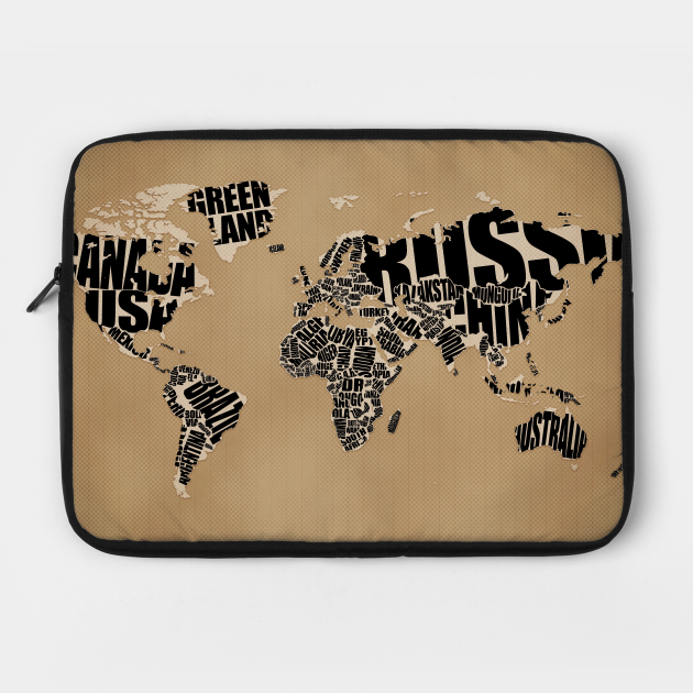
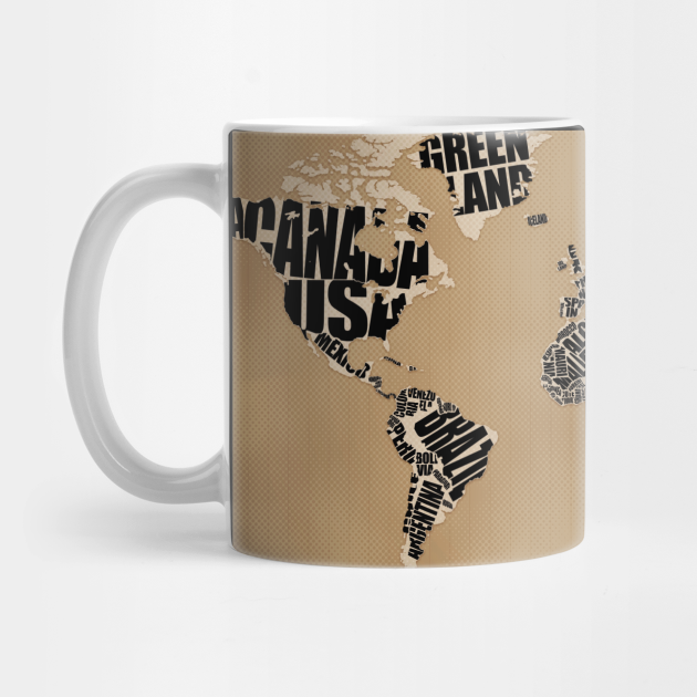
I love drawing world maps! This time, shape of each country is represented by its name.
Anita
15 December 2008
Ha! The first one this time :)
It's a great idea, Vlad! Loooove it :D
Yuriy Gerasimov
15 December 2008
That's incredible. Really.
Richard
15 December 2008
Super cool.
I gotta buy the poster of this.
Feng Wang
15 December 2008
Full of inspiration!
qubra
15 December 2008
very very interesting :)
James Egli
15 December 2008
Very nice, Vlad! Could you do a dual screen version for Mac?
AMPIT
15 December 2008
I like it very much. Thanks. Perhaps try some other colors as well.
-
Manyk
15 December 2008
Outstanding Vlad! Thank you so much for this.
Arielle
15 December 2008
One of a kind. One has to be truly an artist to think of doing something like this. Wonderful & amazing.
Tim
16 December 2008
I got a request for your next map. Can you do one where each country is labeled as what the natives of that country call it. For example Spain would be Espana (which the wavy line over the n) while the U.S. would still be called the United States and Germany would be Deutschland I think.
I hate it when I have to say Estados Unidos is Spanish because I think that the United States should be called the United States, I'm sure some people in Europe feel the same way.
Soleil
16 December 2008
Great idea, Vlad!
But where is Armenia? Not even tiiiiny letters, not even a single letter, nothing! You've just cleared out my country from the world map :))) In fact, there is some space, you could add at least an A or Arm... or you risk to lose some of your returning visitors! :P
16 December 2008
Супер! Мне понравилось
Lukas
16 December 2008
That's so fu**ing awesome :D
marcus
16 December 2008
First to Soleil, do you know how many country's there are in the world... if vlad did put on every country a name, he has to use a microscope to put them there and you for reading it. I thought that Soleil was the french word for SUN,so if you are not happy that there's no letter A on the map of Armenia you have to chance your name to CLOUD, no hard feelings I just wanted to say that...
Second to Vlad, again a lovely masterpiece for us to enjoy...;)
Q: F1,next time?
Grtz from Ostend,Belgium
Leti
16 December 2008
Venezuela looks very nice, thanks Vlad!
Tusnelda
16 December 2008
Different, but I like it! Well done, Vlad!
Ronnie
17 December 2008
Hawaii???
Stas
17 December 2008
Soleil, если уж на то пошло, то для Азербайджана там места больше ;-).
wjy
17 December 2008
perfect!
Warofart
18 December 2008
Amazing concept. Well executed.
Vincent
19 December 2008
No Dual screen
감사해요~
19 December 2008
good~!
Thom
19 December 2008
Any chance of a tutorial? please please please please!!
birol
19 December 2008
vlad this is perfect, really, people will go to buy this as a poster, can you do another work with blue colors?
somebody
20 December 2008
Why there is no word on Taiwan(ROC)?
Taiwan(ROC) and CHINA(PROC) is NOT ruled by one government now.
I hope that everybody can know the fact.
Alexander
20 December 2008
Здорово!!!
22 December 2008
Interesting! It'd be nice if you recognised Tibet!
22 December 2008
@somebody: I'm sure it's just a matter of size...pretty hard to fit anything ledgible into the island. A lot of small countries miss out...I'm sure it's nothing against Taiwan!
Joe..
23 December 2008
waw.. thats creative
Jonathan Schemoul
27 December 2008
No Israel ? :(
Александр
28 December 2008
Суперски
:
28 December 2008
would like a tutorial on the background alone. very nice motif.
Cinzia
29 December 2008
Thank you so much!!! Very very cool (..try some other colors .. yellow... green)
Johan Blixt Dackhammar
29 December 2008
I love this one! And I also think Tim's idea with country names in native languages. Here's a list that could help you with that: http://en.wikipedia.org/wiki/List_of_countries_and_capitals_in_native_languages
z4wil
30 December 2008
Nice artwork Vlad...! Another Map Series :)
Karla
30 December 2008
Me gusta mucho!!!. El manejo de la tipografia y de la creatividad... hacen que se vea sorprendente....
JS
2 January 2009
Nice one Vlad! :)
Soleil, do not say Arm, if he puts that there you will have "Turkey Arm"...I dunno, doesn't sound good :P
Israel, Lebanon and Jordan are missing too...but I cannot fathom how all three can be put in there.
Nikhil Gupta
8 January 2009
Legendary.
Orkhan
9 January 2009
Нет не Азербайджана, не Армении. Не смотря на то что Азербайджан - самая большая страна Южного Кавказа. Интересно :-)
me
19 January 2009
This map is wrong. Canada should go all the way up to the top of the land mass, including all of those islands next to Greenland. That's part of Canada and your map is propaganda!
pete
31 January 2009
sometimes your art makes it very hard to find the right words . its not only unique or beautiful or amazing or talented or or or ...-simply put this is the work of a true genius !
thx for letting us be a part of that :-)
Andrei, Romania
5 February 2009
Great, very good! It's a great idea. Romania is very big and beautiful.
Waddle on!
Borno
5 February 2009
HEY!! you completely left out Bangladesh. (the blank space between india and burma). nice wallpaper though.
alireza
12 March 2009
It's cool.
17 March 2009
very original, i luv it
greetings from Belgium
MIHAELA
1 April 2009
ME A GUSTADOO!
Mark
9 April 2009
And so Tibet gets deleted. swallowed into China, even on maps.....
Саша
3 May 2009
Класс!!
Dani
17 May 2009
amazing!
guppyman
12 October 2009
Soleil, did you know that he excluded not only Armenia, but Monaco, Maldives, The U.A.E, Singapore, Hong Kong, Tibet, Micronesia, Samoa, Polynesia, Palau, Vanuatu, The Mariana Islands, Hawaii, and countless many other nations that deserve the right to leave a mark on the map but can't because they're TOO SMALL!!! Don't blame Vlad for "clearing out" your country.
On this map's scale, which would be about APPROXIMATELY 1cm:1000km, it would be nearly impossible to see your country on it if you don't use a magnifiying glass. BTW, the countries I've listed are either independent sovereigns or federal teritorries.
Vlad Gerasimov
12 October 2009
guppyman: thanks :-)
14 October 2009
You misspelled Kyrgyzstan, Kazakhstan, and Myanmar.
27 October 2009
i love this map it's very beautyful!!
SoapMaker
4 November 2009
I use it on my work laptop to escape a bit, I use it on my wife's pc and it finally found its home on my brand new MBP which will be part of the family for the coming RTW trip. This is great, same for the other MAP oriented stuff and I just wanted to thank you and congratulate for the nice job. so MERCI from Paris.
Danyszheartzz
11 November 2009
Bored
Erika
16 December 2009
Very nice but it would be even nicer if it were availble in different backround-colours. Pretty pretty please Vlad or maybe Santa :)
Thanks!
Joe
28 December 2009
I think u missed Alaska as part of USA
Marcos Argentina
6 May 2010
Very nice pic!! really hard work
stav
18 May 2010
hey m8!
I noticed you didn't put Israel on your maps and it really bothered me.
i hope it's just because of it's size and if not ill be happy to hear why.
(BTW you are losing a LOT of potential costumers here in Israel because of that- i know a lot of people who really love your painting and just don't want to fund anti-Israelism)
thanks!
Spdyrel
18 June 2010
Great wallpaper, had to manually add Israel though.
llledo
2 July 2010
wow
Ksenia
18 July 2010
ho ho ho Russia is very very огромная)
esiak
13 August 2010
hi:) you are featured here: http://esiak-noart.blogspot.com/2010/08/stunning-typography-wallpapers.html
Megan
9 October 2010
Kazakhstan is misspelled.
Immanuel
24 October 2010
Hi,
Can I use your wallpapers for non-profit designs?
5 February 2011
sichimichia
milly
26 February 2011
very creative... just would like to know- is it intended or not cos your whole world, by colour and way of using letters, makes me think of Africa...
My name
12 April 2011
Cool!
Dogukan Hazar Goksel
15 April 2011
Perfect!!!
Igor
17 April 2011
I am using this as my Mac skin as well as my Blog and Twitter background (igorristic.wordpress.com). I love it, and hope that you are okay with me using it!
21 January 2012
Istanbul, ...
ash
4 February 2012
Would have loved to buy it but you left out ISRAEL!
Diana
8 July 2012
This is perfect! I am making a card for my friend, and this is sitting in great! THANK YOU!
Marco
6 January 2013
Hey just to made your concept even better. I think that the "U" in USA is taking some of Mexico's Baja Peninsula (http://en.wikipedia.org/wiki/Baja_California_Peninsula)
Great wallpaper by the way.
Regards
jonnydep
18 June 2013
Как скачать ???
ran
19 September 2013
Thanks!
abolfazl
3 October 2013
i loooooooooooooooooooooooooove iran
Marije
25 October 2013
Hello Vlad, love this map. Do you have the map as vector or bigger than 2880*1800? Would love to have it printed 3mx6m and these files are not big enough. Please email me marijepauliendebruin@hotmail.com
hihihuikjko
13 March 2014
cool.Modern
FAN
28 March 2019
KEEP UP THE GREAT WORK!